Be Ready for Hurricane Season. Knowing the Hazards, Understanding Forecast Information, and Connecting With the Right Resources Are Key Factors in Being Prepared.
Information on this page:
Section 1: What is a Tropical Cyclone?
Section 2: Primary Hazards from Hurricanes
Section 3: Understanding Forecast Information
Section 4: Useful Resources

What is a Tropical Cyclone?
A tropical cyclone is a rapidly rotating storm that begins over tropical oceans and can vary in speed, size, and intensity. Tropical depressions, tropical storms, and hurricanes are all types of tropical cyclones, with the most dangerous being hurricanes. The Atlantic Hurricane Season runs from June 1st to November 30th every year. Each year, tropical cyclones cause multiple casualties, deaths, and significant damage to property and infrastructure in the immediate term.
Potential Tropical Cyclone: A disturbance that is not yet a tropical cyclone but poses a threat of bringing tropical storm or hurricane conditions to land areas
Tropical Depression: A tropical cyclone that has maximum sustained surface winds of 38 mph or less
Tropical Storm: A tropical cyclone that has maximum sustained surface winds ranging from 39 to 73 mph.
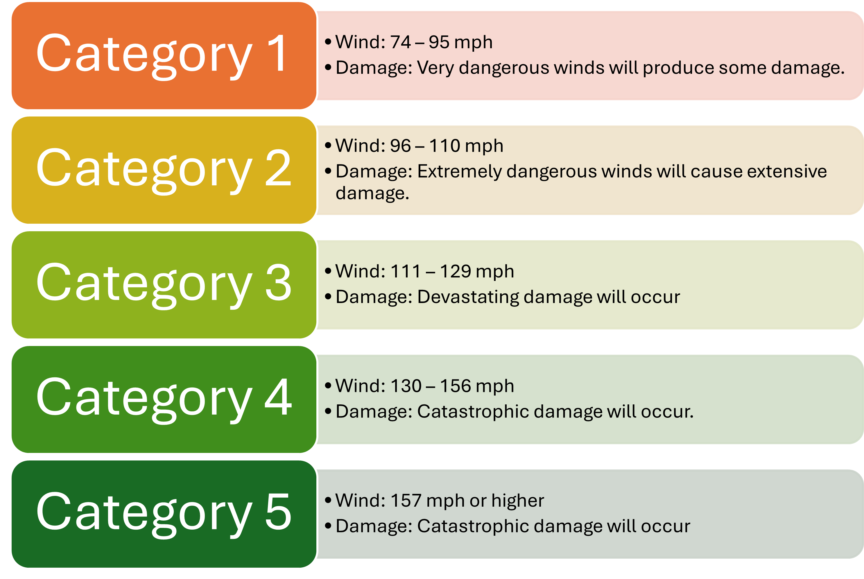
Hurricane: A tropical cyclone that has maximum sustained surface winds of 74 mph or greater. The Saffir-Simpson Hurricane Wind Scale is a 1 to 5 rating based on a hurricane’s sustained wind speed, hence why there are 5 hurricane categories.
Major Hurricane: A hurricane that is classified as Category 3 or higher is considered a major hurricane.
Primary Hazards From Hurricanes
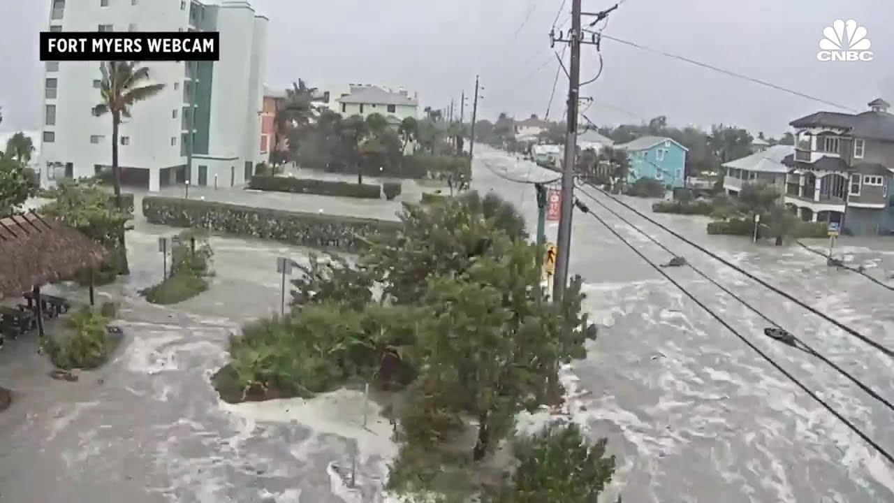
Storm surge is the inundation from rising water moving inland from the shoreland. It is considered the greatest threat to life from a tropical cyclone because it is historically the leading cause of hurricane-related deaths in the United States. Storm surge has the ability to travel several miles inland, especially along bays, rivers, and estuaries. According to the 2019 Storm Surge Report, Florida is the most vulnerable to storm surge with 2.9 million homes at risk (which is more than double the next highest vulnerable state: Louisiana with 847,000 homes at risk).
Evacuation zones identify areas prone to storm surge inundation during a tropical cyclone event and determined by local emergency managers. Evacuation zones do NOT relate to inland flooding or flood zones. To find your evacuation zone, visit the Florida Department of Emergency Management page on evacuation zones.
Hurricane categories are based on wind speeds; the higher the category, the stronger the winds. Winds from a hurricane can destroy buildings and manufactured homes. Signs, roofing material, and other items left outside can become flying missiles during hurricanes. Compromised trees or limbs may also fall, blocking roadways and downing power lines
Click here for tips on how to protect your home before a high-wind event, such as a tropical cyclone.
Flooding from heavy rains is the second leading cause of fatalities from landfalling tropical cyclones. Widespread torrential rains associated with tropical cyclones often cause flooding hundreds of miles inland. This flooding can persist for several days after a storm has dissipated., producing additional hazards, such as compromised infrastructure, submerged hazards, and contaminated water. While the hurricane category provides a wind speed range, it does not provide any information on the amount of rainfall that will be produced by a hurricane.
Flood zones are mapped by the Federal Emergency Management Agency (FEMA). They provide information to residents regarding the risk of property flooding from general flooding due to various factors like heavy rainfall, swollen rivers, and coastal flooding. Flood zones do NOT relate to storm surge.
Use the links below to find more information.
Tornadoes can accompany landfalling tropical cyclones. They typically occur in rain bands well away from the center of the storm. Due to the destructive nature of tornadoes, they can produce cascading hazardous conditions. For example, debris from a tornado become additional flying hazards. Infrastructure and utilities could become compromised and susceptible to other hurricane hazards.
Dangerous waves produced by a tropical cyclone's strong winds can pose a significant hazard to coastal residents and mariners. These waves can cause deadly rip currents, significant beach erosion, and damage to structures along the coastline, even when the storm is more than 1,000 miles offshore.
Understanding Forecast Information
We can gain a better understanding of the information being provided to us based on the source of the information
Tha National Hurricane Center will provide storm-scale forecast information, which includes the size, intensity, and track of the cyclone. This information provides impact information on a regional scale.
On the other hand, local National Weather Service offices provide local area forecasts, which include more specific details on what to prepare, who should be preparing, and when they should be preparing. They provide county- to city-level impact information.
Additionally, it is important to properly interpret graphics presented, such as the NHC forecast cone. Cones display the most likely track of storm CENTER; it does NOT show areas that could be affected. The cone size also does not change from storm to storm. The NHC uses colors to represent which counties are under watches and/or warnings.

Get Prepared, Stay Prepared: Helpful Resources
-
Wireless Emergency Alerts
Toggle More Info -
National Oceanic and Atmospheric Administration (NOAA) Weather Radio
Toggle More Info -
Lee County All Hazards Guide
Toggle More Info -
WGCU Public Media App
Toggle More Info -
Disaster Behavioral Health
Toggle More Info -
Food and Water Safety During Hurricanes
Toggle More Info -
Atlantic 7-Day Graphical Tropical Weather Outlook
Toggle More Info
FEMA Hurricane Information NOAA Hurricane Preparedness