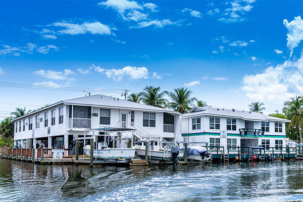
A Waterfront Nexus for Studying the Natural World
Our unique facility in nearby Bonita Springs serves as an easy-access point to Estero Bay and the Gulf of Mexico and is an important base of operations for studies of Southwest Florida’s coastal and watershed habitats.
About Vester Field Station
A resource for FGCU faculty and students, as well as researchers from throughout Florida and the United States, Vester has also hosted scientists from 15 foreign nations. Located 12 miles from the FGCU campus on Little Hickory Island, our field station sits along Fish Trap Bay, where the Imperial River empties into Estero Bay. Its three buildings perch on a spit of land that formerly held a commercial fish house, then an old Florida-style resort.

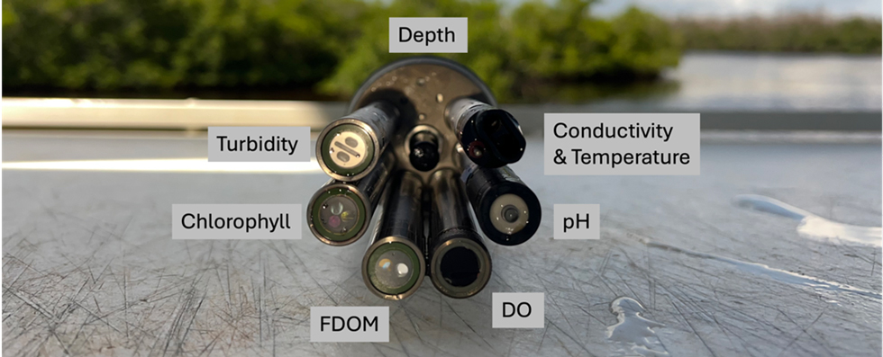
FGCU Water Quality Monitoring
This data is part of the FGCU Vester Field Station’s water quality monitoring network
across southwest Florida. This is a funded project through the Southeast Coastal Ocean
Observing Regional Association (SECOORA) that supports four stationary locations equipped
with YSI EXO2 datasondes to collect temperature, conductivity, salinity, pH, turbidity,
DO, depth, FDOM, and total algae every 10 minutes.
Check out the LOCAL, REAL-TIME data on WQDataLive.
Share your experience with the water quality data
Each Parameter Measures a Different Aspect of Water Quality
Temperature (C)
Water temperature measured in degrees Celsius.
Sp Cond (µS/cm)
Specific Conductivity is the ability of water to conduct an electrical current. It gives a good idea of the amount of dissolved material in the water.
Salinity (PPT)
The amount of dissolved salt content in the water measured in parts per thousand.
pH
Measure of how acidic/basic the water is.
Depth (m)
How deep the water currently is measured in meters.
Turbidity (NTU)
Measure of the level of particles in the water. It can lead to cloud waters.
Chlorophyll (µg/L)
Measurement of chlorophyll in the water. It is a good indicator of phytoplankton and algae growth as most photosynthetic organisms contain chlorophyll.
ODO (mg/L) and ODO (%)
The amount of oxygen present in the water. It is measured in mg/L and percentage.
FDOM QSU
Fluorescent dissolved organic matter is the measure of dissolved organic matter in the water.
This data is used for many research projects at the Vester Field Station, such as oyster monitoring, seagrass monitoring, and Florida red tide monitoring. Students can use this data for their own research projects for classes as well as faculty to teach about local water quality issues. Local beach goers and boaters can use this data to look at current water quality conditions before going out on the water.
Monitoring technology such as a YSI EXO2 datasonde is helpful as it can provide more insight into water quality trends over time. Previous water quality monitoring methods included collecting grab samples once a month. These monthly samples cannot provide information on daily, tidal, and/or seasonal changes. The added livestreaming capacity allows for users to have real-time data that grab samples cannot provide.
Florida is known to have harmful algae blooms (HABs), such as Florida red tide, that can cause toxic waters and mortalities for many marine species. HABs occur when toxic phytoplankton populations grow too rapidly. Chlorophyll is a great indicator for HAB presence, as it is found within most phytoplankton species. Using chlorophyll concentrations can increase the monitoring efforts towards detecting HAB events along the SWFL coast.
For more information on the data please contact Kayla Hughes at khughes@fgcu.edu.
![]()

Kimberly's Reef
Kimberly's Reef is FGCU's official research reef which is located 10 miles offshore in the Gulf of Mexico in 30 feet of water, the FGCU artificial reef brings a living laboratory to the coastal waters off Collier and Lee Counties – only a 25-minute boat ride away. The reef’s size and location lends itself to essential research and community outreach.
Marine Science Summer Camp
Registration will open on April 15th, 2026
Incoming 6th - 8th graders : 5 days in the classroom, lab and field led by FGCU Students
Session 1: June 8th - 12th
Session2: June 22nd - 26th
For more information contact fsheikh@fgcu.edu or nculligan@fgcu.edu
Facilities
Vester is outfitted to accommodate diverse instructional programs and research projects — indoors and out, on the water and in the labs.
-
Vessel Fleet
Toggle More Info -
Laboratories
Toggle More Info -
Hatchery
Toggle More Info -
Classrooms, Workrooms, and Conference Room
Toggle More Info -
Housing
Toggle More Info -
Research Tools
Toggle More Info
Contact Us
Farida Sheikh
Administrative Assistant
Vester Field Station
5164 Bonita Beach Rd SW
Bonita Springs, FL 34134
Phone: 239-745-4707
Email: fsheikh@fgcu.edu